


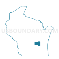
FOREST - T 1 Voting District, Fond du Lac County, Wisconsin
About
Outline

Summary
| Unique Area Identifier | 693779 |
| Name | FOREST - T 1 Voting District |
| County | Fond du Lac County |
| State | Wisconsin |
| Area (square miles) | 29.14 |
| Land Area (square miles) | 28.65 |
| Water Area (square miles) | 0.49 |
| % of Land Area | 98.33 |
| % of Water Area | 1.67 |
| Latitude of the Internal Point | 43.75341690 |
| Longtitude of the Internal Point | -88.20928720 |
Maps


Graphs
Select a template below for downloading or customizing gragh for FOREST - T 1 Voting District, Fond du Lac County, Wisconsin


Neighbors
Neighoring Voting District (by Name) Neighboring Voting District on the Map
- EMPIRE - T 1 Voting District, Fond du Lac County, WI
- EMPIRE - T 3 Voting District, Fond du Lac County, WI
- FOREST - T 2 Voting District, Fond du Lac County, WI
- GREENBUSH - T 1 Voting District, Sheboygan County, WI
- GREENBUSH - T 2 Voting District, Sheboygan County, WI
- GREENBUSH - T 3 Voting District, Sheboygan County, WI
- MARSHFIELD - T 2 Voting District, Fond du Lac County, WI
- MITCHELL - T 1 Voting District, Sheboygan County, WI
- OSCEOLA - T 1 Voting District, Fond du Lac County, WI
- OSCEOLA - T 2 Voting District, Fond du Lac County, WI
Top 10 Neighboring County Subdivision (by Population) Neighboring County Subdivision on the Map
- Empire town, Fond du Lac County, WI (2,797)
- Mitchell town, Sheboygan County, WI (2,335)
- Osceola town, Fond du Lac County, WI (1,865)
- Greenbush town, Sheboygan County, WI (1,534)
- Marshfield town, Fond du Lac County, WI (1,138)
- Forest town, Fond du Lac County, WI (1,080)
Top 10 Neighboring Unified School District (by Population) Neighboring Unified School District on the Map
- Fond du Lac School District, WI (52,450)
- Plymouth School District, WI (16,964)
- Campbellsport School District, WI (10,613)
- Elkhart Lake-Glenbeulah School District, WI (3,816)
Top 10 Neighboring State Legislative District Lower Chamber (by Population) Neighboring State Legislative District Lower Chamber on the Map
- Assembly District 53, WI (59,677)
- Assembly District 59, WI (58,836)
- Assembly District 27, WI (56,118)
Top 10 Neighboring State Legislative District Upper Chamber (by Population) Neighboring State Legislative District Upper Chamber on the Map
- State Senate District 20, WI (176,381)
- State Senate District 18, WI (170,917)
- State Senate District 9, WI (162,219)
Top 10 Neighboring 111th Congressional District (by Population) Neighboring 111th Congressional District on the Map
Top 10 Neighboring Census Tract (by Population) Neighboring Census Tract on the Map
- Census Tract 420, Fond du Lac County, WI (8,718)
- Census Tract 419, Fond du Lac County, WI (7,180)
- Census Tract 421, Fond du Lac County, WI (4,927)
- Census Tract 111, Sheboygan County, WI (4,171)
- Census Tract 104, Sheboygan County, WI (2,622)
Top 10 Neighboring 5-Digit ZIP Code Tabulation Area (by Population) Neighboring 5-Digit ZIP Code Tabulation Area on the Map
- 54937, WI (19,112)
- 53073, WI (15,757)
- 53010, WI (7,681)
- 53019, WI (2,027)
- 53057, WI (1,928)
- 53023, WI (1,496)
- 53079, WI (1,413)